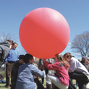
Up, up and away. Aerial photography is now in the hands of the masses thanks to the efforts of groups like PLOTS and Parts and Crafts. – Photo by Amanda Rhodes
By Amanda Rhodes
If you were in Davis Square on Saturday, you might have noticed a big, red balloon hovering high in the sky. You might not have noticed the camera attached to it. The camera and the balloon were part of a grassroots mapping event hosted by the Public Laboratory for Open Technology and Science (PLOTS) and Parts and Crafts.
The idea is to put mapping in the hands of ordinary people, both kids and adults, who then have information and power to understand, reframe, and possibly re-imagine the neighborhood or site being mapped. By attaching a point-and-shoot camera that is operating in continuous mode, one is able to take aerial photos by using a helium-filled balloon or kite to lift the camera high in the sky. Mapping by aerial photo is best done during this time of year, before the leaves are back on the trees and the sidewalks and open spaces become obscured.
Saturday was windy enough that two kites were able to be launched, but everyone was eager to see the 5 ft. wide balloon take flight. As Jeffrey Warren, Research Director at Public Lab, pointed out “It’s kind of like surfing. You can do it anytime, but it’s not going to be optimal. You have to know the weather.”
The plan was to launch the balloon, take some photos, bring it down to view the photos, and then launch it again. Unfortunately, the balloon popped in the air and the camera had to be rescued from the power line where it was entangled. However, the camera was still able to take photos of Davis Square and the results can be seen on the PLOTS website.
For many people at the event, this was their first attempt at balloon mapping. A few of the participants had tried it before and talked about the challenges they faced and the solutions they found. One issue is protecting the camera, which can be accomplished cheaply and easily with a used soda bottle. The repurposed bottle creates a shell to protect the camera from unplanned landings, dirt, and sand. Attaching wings to the bottle helps stabilize it and keeps it from spinning in the air. Another challenge is the storage and battery capacities of a digital camera. Shooting photos in continuous mode drains the battery quickly, while filling up the memory card. One group said they had found one solution to this problem: they activated the flash mode and taped over the flash so the photos did not become overexposed.
That is part of the fun of the activity. There is a specific goal, but there are many challenges and many solutions. Each person has to approach the task and think through the whole scenario. It is both fun and educational.
PLOTS was founded in response to the 2010 BP Oil Spill, but the group and its movement are really about exploring the environment and understanding its social and political implications through the use of open-source hardware and software tools. As the organization’s website states: “Public Laboratory creates a collaborative network of practitioners who actively re-imagine the human relationship with the environment… Our goal is to increase the ability of underserved communities to identify, redress, remediate, and create awareness and accountability around environmental concerns.”
The balloon only took flight once, but that one trip made quite an impression on the group of people who gathered on Saturday morning. To find out more about PLOTS and Do-It-Yourself mapping, visit http://publiclaboratory.org/home. For more information on Parts and Crafts and the programs and camps it offers, visit the website at http://partsandcrafts.org/.


Reader Comments