Pages
Stay In Touch
More
© 2026 The Somerville Times. All rights reserved.

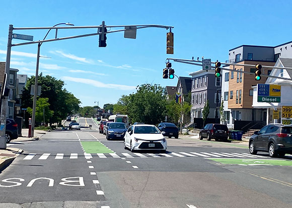
Concept designs for the Broadway Magoun Reconstruction Project were recently presented to the public. — Photo by Bobbie Toner
By The Times Staff
The Broadway Magoun Reconstruction Project presentation on May 26 provided an overview of the concept design made by the project team.
“The goal of this project is to improve safety, accessibility, transit operations, and the overall experience for everyone who uses the street, whether walking or rolling, biking, taking public transit, or driving,” said Lillian Worth, transportation planner at OSPCD.
This project is part of the city’s Pavement and Sidewalk Management Program, which prioritizes streets for reconstruction based on safety, accessibility, and equity considerations, as well as the condition and function of the street.
The roadway project will consist of reconstruction on Broadway from Winchester Street to Central Street. The reconstruction effort will include full sidewalk and curb reconstruction, repaving the roadway, adding tree plantings, adding new crosswalks, including raised crossings, traffic signal changes, protecting the existing bicycle infrastructure, making improvements to bus stops, intersection redesign, changes to sidewalk and lane widths, parking regulation changes, and adding new accessible parking spaces.
The city is still considering additional elements such as traffic calming on nearby streets, changes to directionality and operation of streets, and adding new planting and landscaped areas.
Concept designs for Broadway
Winchester Street, which is the western limit of the project area, was reconfigured about five years ago to tighten up what was formerly a very wide intersection, she said. A pedestrian refuge island was added to the crosswalk to help people cross the street safely.
“Our project picks up here and proposes additional curb islands to shorten the pedestrian crossing and to help encourage slower vehicle speeds,” said Worth, recalling that community members had voiced concerns about vehicles speeding down the hill as they drove off the Ball Square Bridge.
Moving along eastward, the existing bike lanes will be protected with concrete curbing and the bike lane on the north side will be moved adjacent to the curb in between parked cars and the general travel lane.
Broadway is generally quite wide, so parking will remain on both sides of the street for almost all the sections in the project area, she explained.
Moving along to Broadway and Cedar Street, there are several proposed changes.
“We’re proposing to move the bus stop on the north side to the far side of the intersection, which will help the bus get through faster since it will no longer have to stop twice,” said Worth.
This change will allow additional parking spaces, east of Alfred Street, outside the businesses.
The city is proposing floating bus stops, which are located off the curb with the bike lane passing behind. These floating bus stops have a number of benefits, including helping buses move faster since they no longer would have to pull in and out of traffic. This would then add more space for people to wait, she explained.
The bike lanes would be narrowed and would have a ramp up and down to slow the speeds for people biking in order to prioritize people using the bus stop. The bus stop on the south side of Broadway adjacent to Trum Field would also be a floating bus stop, according to the concept design.
In terms of signal operations, new signal equipment would separate out right turning traffic from people biking straight on Broadway. “We heard from a lot of community members that raised this safety issue since there are a lot of right turning cars from Broadway onto Cedar,” said Worth.
Additionally, the unsignalized crosswalk at Alfred Street will be narrower than it is today to reduce pedestrian exposure to turning traffic. “Right now, it’s a pretty long crosswalk and it can be pretty uncomfortable,” added Worth.
Continuing to move east, the proposed plan would also create curb extensions at William Street, similar to Alfred Street.
“The crosswalk here is very long and people driving can take very wide turns at high speeds,” said Worth. The proposed changes will shorten the crosswalk and will also add more pedestrian space.
At Charles E. Ryan Road – a street named to honor the World War 1 hero – the team is proposing to create a raised crosswalk with curb extensions to improve crossing experiences and slow vehicle speeds.
On the north side of Broadway, east of William Street, there is an opportunity to significantly widen the sidewalk. “This area has the narrowest sidewalks around Magoun Square and also happens to have many businesses,” said Worth. “Since we are already significantly altering the curb line, we propose to fully raise the bike lane here and have a sidewalk level facility fully separated from the pedestrian space.”
Due to a variety of reasons, including cost, the project team is proposing street level bike lanes for large portions of the project area, but they are prioritizing sidewalk level facilities at key areas, including intersections, floating bus stops, and conflict points.
The project team is proposing to remove the bus stops by William Street and Charles E. Ryan Road. This change would improve bus speeds and is in line with the MBTA’s preferred stop spacing.
“Additionally, this bus stop has the second lowest ridership of the entire project area with most people preferring to use the stop closer to the square,” she said. Changing this will also allow new parking to be added on the block between Charles E. Ryan Road and Hinkley Street.
On the other side of the intersection for Broadway heading up to
Winter Hill, some community members asked for medians. But others preferred no medians, and asked that the space be reallocated to wider sidewalks. “This is a choice that will be made further along in the design process as we know more about what the intersection might look like,” said Worth.
The project team is proposing an entirely new raised crosswalk across Broadway at Norwood Avenue. Currently, the roadway cross-section at the top of the hill is too narrow to allow two travel lanes, two parking lanes, two bike lanes, and two actual sidewalks.
“So, for this reason, we propose removing the parking along the north side so that the parking remains on the south side adjacent to residences,” she said. This space will also allow added protection to the bike lane, which is currently unprotected.
Currently, the bus stops in this area are far apart from each other, said Worth, so the team is proposing to relocate the bus stop on the north side to be closer to its pair at Bartlett Street.
Crosswalks at Bartlett Street and Glenwood Road will likely be raised crosswalks to help reduce speeds and make a safer crossing experience.
“We’re proposing a raised crosswalk across Broadway at Central Street, which was another location where we heard a lot of safety concerns in our first public outreach,” said Worth.
Magoun Square intersection alternatives
The project team evaluated options and listened to feedback from the community, but they also took a look at the data.
“We recorded turning movements to understand where traffic moving through the intersection was coming and going from. And we also modeled traffic patterns in the wider area to understand the overall impacts on the neighborhood,” said Worth.
The first option is a modern roundabout. “The reason that it’s not a perfect circle is that the kind of unique shape of the intersection means it’s a lot easier for larger vehicles to get through with a sort of elongated almost like an avocado or peanut shape,” said Worth.
The roundabout would include raised crosswalks and flashing pedestrian beacons to make it easier to cross. It would also add separated bike lanes around the intersection. And there would be floating bus stops on the near side of the intersection to provide improved bus operations without gridlocking the intersection.
Some of the advantages include minimal traffic delay, shorter crossings, and fewer vehicle conflicts. However, there are some potential drawbacks, explained Worth. Some people walking and biking may feel less comfortable without traffic signals. Crosswalks would be set back a little further from the intersection than they would be under different options. And a lot of the reclaimed pedestrian space would be in the center of the roundabout. Plantings could be placed in that area, she said, but it wouldn’t be easy to access or functionally usable.
Design option two, the project team is calling “X.” This option simplifies the intersection into a more traditional four-way layout. This design maintains traffic signals, but it removes extra travel lanes that aren’t needed. It adds raised and protected bike lanes. It includes floating bus stops at the far side and expands pedestrian space at the corners.
The “X” plan also includes an exclusive pedestrian phase, so after the vehicle phases go, all traffic stops, and people can cross in any direction, the same as how things operate today, but with a much shorter wait, explained Worth.
Benefits include reduced crossing distances, improved pedestrian space, simpler traffic operations, and reduced delays overall.
There are some trade-offs though in terms of the operations of Dexter Street. Cars coming out of Dexter Street would be restricted to right turns only. It’s completely removed from the signal. It doesn’t have its own dedicated phase. And also, there is a little bit more exposure and interaction between bikes and vehicles, explained Worth. There are protected corners for people biking in this design.
The project team is calling the third alternative, the “T” because it tees off Medford Street into Broadway and reorganizes. This design provides the greatest separation between travel modes, said Worth. It includes protected bike lanes with dedicated bike signals. It maintains traffic signals, but it still simplifies the operations compared to existing conditions.
Benefits include shorter crossings, more pedestrian space, particularly at the corners, and reduced overall delay for all users. Trade-offs would include some restricted turning movement. Similar to the “X” option, Dexter Street would be a right turn only, and for the “T” alternative, left turns from Broadway onto Medford Street would be prohibited.
There’s also a slightly less direct path of travel for cyclists compared to other concepts, resulting in a slightly longer crossing distance, she explained.
The project team is continuing to gather community feedback on all these intersection alternatives and on the broader corridor design.
An 80 percent design is expected in the fall, and following that, the team will have an additional round of community engagement.


Reader Comments